1788 – John Harrison’s
Map of Hampshire

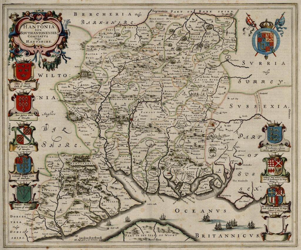
The Hampshire county map issued by John Harrison was first published on 16 December 1788 and later included in his 1791 atlas of England and Wales. Harrison was a London publisher operating from 115 Newgate Street, and his atlas formed part of the late eighteenth-century expansion of commercially produced county cartography.
The map is titled A Map of Hampshire and was engraved at a scale of approximately six miles to one inch. It was drawn by Haywood and engraved by Sudlow, reflecting the increasingly specialised division of labour typical of eighteenth-century map production. By this period, it was common practice for surveyors or draughtsmen to prepare the original drawing, with professional engravers transferring the design onto copperplate for printing.
Harrison’s atlas contained 38 engraved county maps accompanied by extensive printed gazetteer text. The gazetteer material was issued on separate pages from the maps and provided descriptive and administrative information relating to each county. This included lists of county subdivisions such as Hundreds, parishes, market towns, and other civil divisions. Hambledon, for example, is recorded as one of the Hundreds within Hampshire. The inclusion of structured gazetteer information reflects the late eighteenth-century emphasis on administrative geography and statistical description.
The Hampshire map itself represents the more mature cartographic conventions of the period. Compared with earlier seventeenth-century county maps, it includes a clearly delineated road network, reflecting the importance of turnpike roads and improved inland communications during the eighteenth century. Principal towns are marked distinctly, and numerous smaller settlements are named. Rivers, coastal features, and estuaries are shown with greater precision than in earlier engraved county maps.
Relief is indicated through engraved shading and hachuring rather than pictorial hill symbols. County boundaries are clearly defined, and in many eighteenth-century county maps, internal divisions such as Hundreds are either marked or referenced in the accompanying text. The coastline along the Solent and the English Channel is rendered with the improved geographic knowledge available by the late eighteenth century.
The map was printed from a copperplate and commonly issued in hand-coloured form. Colouring was applied after printing, typically to emphasise county boundaries and occasionally to distinguish internal divisions. As with other maps of the period, the intensity and neatness of colouring vary between surviving examples.
Harrison’s atlas belongs to a period in which English county mapping had become both standardised and widely accessible. By the 1780s, printed county maps were no longer pioneering surveys but established commercial products aimed at a broad readership that included landowners, travellers, and administrators. The combination of engraved county maps and substantial gazetteer text reflects the late Enlightenment interest in systematic geographic description and the practical needs of governance and travel.
The Hampshire map of 1788–1791 therefore represents a later stage in the development of county cartography: more detailed in road representation, administratively structured, and integrated into a descriptive atlas format designed for practical reference rather than courtly or decorative display.